Jennifer M. Klein, Esq.
Associate Director & Fellow
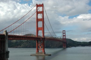
 Sea level rise is a “pervasive and increasing threat” and should be evaluated as infrastructure projects are built or modified along San Francisco’s shorelines, according to Guidance adopted by San Francisco’s Capital Planning Committee (CPC) on September 22. San Francisco, bordered by the Pacific Ocean to the west and the San Francisco Bay to the north and east, is already experiencing periodic inundation and erosion, which will be exacerbated by sea level rise. The new Guidance asserts that planning efforts “must incorporate the latest climate science to determine how to protect and modify existing assets and design new assets to be more resilient to rising seas.”
The Guidance provides a step-by-step approach for city and county departments to assess sea level rise vulnerability within the capital planning process: First, departments must review the current science, including projections of sea level rise, storm surge, and waves. Second, infrastructure plans should include a vulnerability assessment, in which departments evaluate the degree to which an asset will be exposed and affected by flooding. Third, departments should consider the consequences of potential infrastructure damage, including the cost of reconstruction or repair, the economic impact of disruption, and the irreversibility of the impact. Finally, planners should identify and evaluate appropriate adaptation strategies. The CPC intends for this approach to assist departments in identifying effective adaptation measures, which will depend on the particular site and project at issue.
The Sabin Center for Climate Change Law (SCCCL) recently urged federal agencies to consider sea level rise in connection with coastal infrastructure projects. San Francisco’s efforts to promote adaptation are a welcome step towards ameliorating the projected physical impacts of climate change on our infrastructure, economy, and communities.


